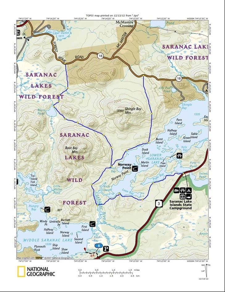
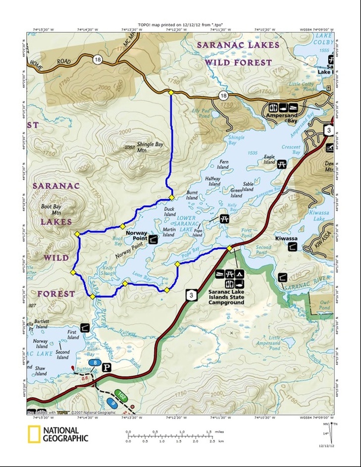
Trail #10 - Black Pond to Lower Saranac Lake - See the details here: http://www.broadwingadventures.com/1/post/2012/12/trail-10-10-trails-we-should-build-before-we-worry-about-converting-rails-to-trails.html
| LEADING E.D.G.E. |
|
|
Trail #10 - Black Pond to Lower Saranac Lake - See the details here: http://www.broadwingadventures.com/1/post/2012/12/trail-10-10-trails-we-should-build-before-we-worry-about-converting-rails-to-trails.html
1 Comment
Here's trail #8: Scarface Mountain Loop http://www.broadwingadventures.com/1/post/2012/12/trail-8-10-trails-we-should-build-before-we-worry-about-converting-rails-to-trails.html 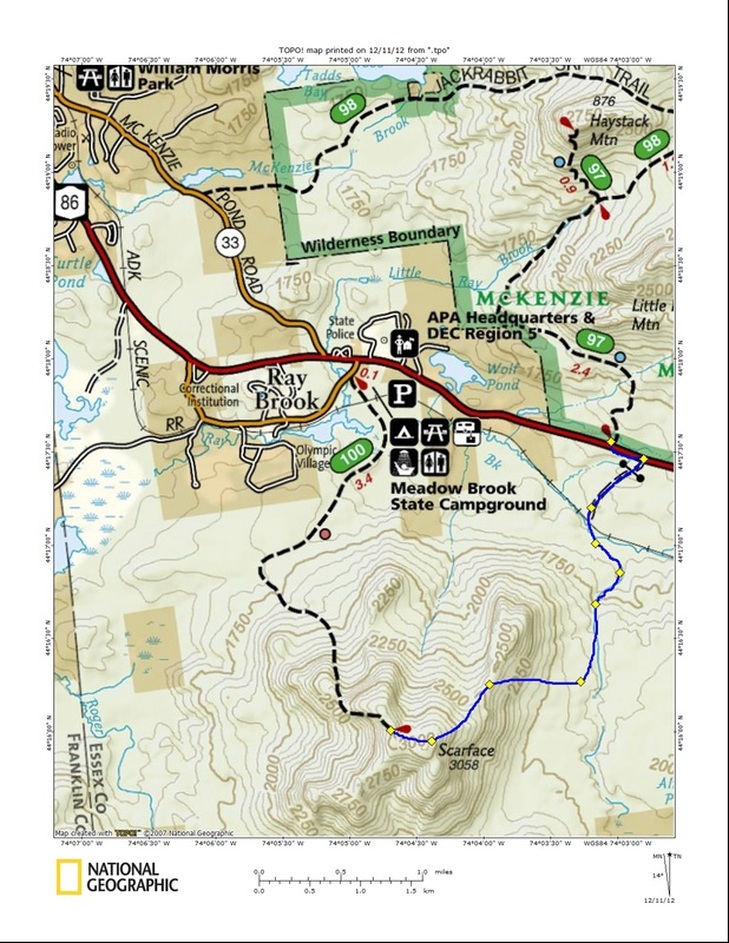
Trail 5, 6 & 7 - 10 Trails We Should Build Before We Worry about Converting Rails to Trails12/10/2012 Here are the trail posts for the last few days at: http://www.broadwingadventures.com/broadwing-blog.html
The latest Trails AND Rails post is up at: http://www.broadwingadventures.com/1/post/2012/12/trail-4-10-trails-we-should-build-before-we-worry-about-converting-rails-to-trails.html 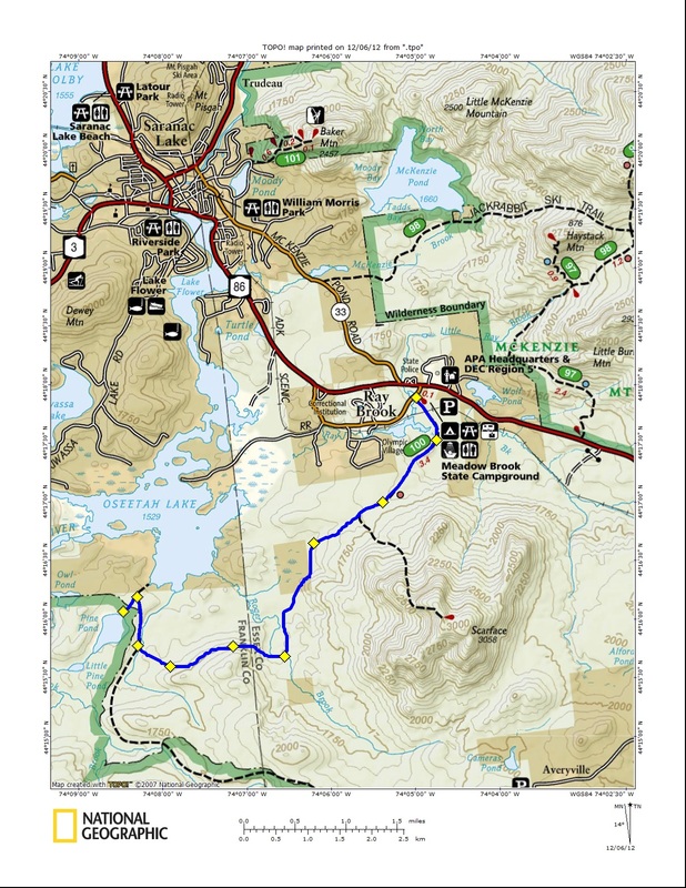
The latest Trails AND Rails post is available at: http://www.broadwingadventures.com/1/post/2012/12/trail-3-10-trails-we-should-build-before-we-worry-about-converting-rails-to-trails.html 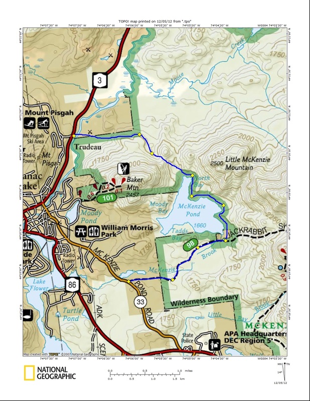
Thank you for following along on the Leading E.D.G.E blog on the Rails AND Trails issue. I have decided to make all posts on our Broadwing Blog. It has become too much work to post them twice.
Here's the Link: http://www.broadwingadventures.com/1/post/2012/12/trail-2-10-trails-we-should-build-before-we-worry-about-converting-rails-to-trails.html 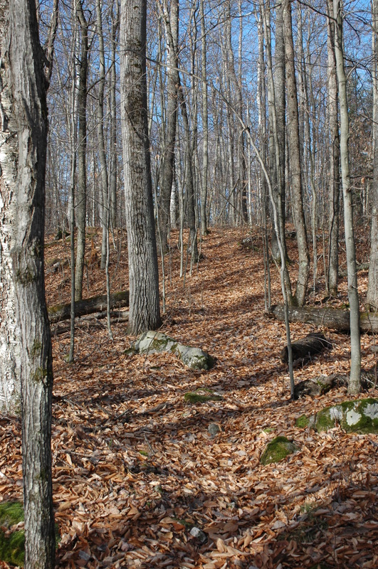 A trail that could be made a destination close to downtown Saranac Lake. Introduction The effort by the Adirondack Recreation Trail Advocates (ARTA) to create “a contiguous recreation trail from Lake Placid to Old Forge” is a laudable one. The concept of a recreation trail between these two communities on its surface sounds appealing. ARTA however has created the classic novel story line in that every good story has to have a protagonist, in this case ARTA, the good guys, and an antagonist, the bad guys, in this case the Adirondack Scenic Rail Road. Of course if you are the Adirondack Scenic Rail Road you may see it the other way around. History usually determines which is which. The winners end up being the protagonist and the losers the antagonist. I prefer to look at it differently. I have an affliction called rationality. As one friend once wrote, “It’s Jack’s most honored virtue.” I like to find win-win solutions to problems. I’ve always preached to my students to use the rational decision-making/problem-solving process. One of the first steps of problem solving is to define the problem. It appears that the anti-train people define the problem as, we need more recreational trails in the Adirondacks, the railroad is a mode of transportation whose time has passed, so let’s tear up the rails and use the money from salvaging the iron and build a multi-purpose trail from Lake Placid to Old Forge. As a recreation professional with over 40 years of experience I see the problem a little differently. The problem, as I see it, is that most Adirondack communities lack easy access trails that you can reach from your home or motel room. The problem is, how can we remedy this? I’m continually amazed as I travel around the world how much easier it frequently is to find beautiful terrain to walk through in urban areas than it is in my hometown of Saranac Lake. That needs to change here in Saranac Lake as well as other Adirondack towns and villages. The solution is much simpler than what than what the anti-train people advocate. The solution is a series of interconnected trails accessible from numerous access points. I’m going to suggest 10 trails for Saranac Lake as an example. I’m calling the list, “10 Trails We Should Build Before We Worry About Converting Rails to Trails.” I’m going to share 1 trail a day here over the next 10 days with an accompanying map. Before I begin let me make a few points.
Below is the map and description of the first trail. Tune in tomorrow for the second trail. Jack Drury 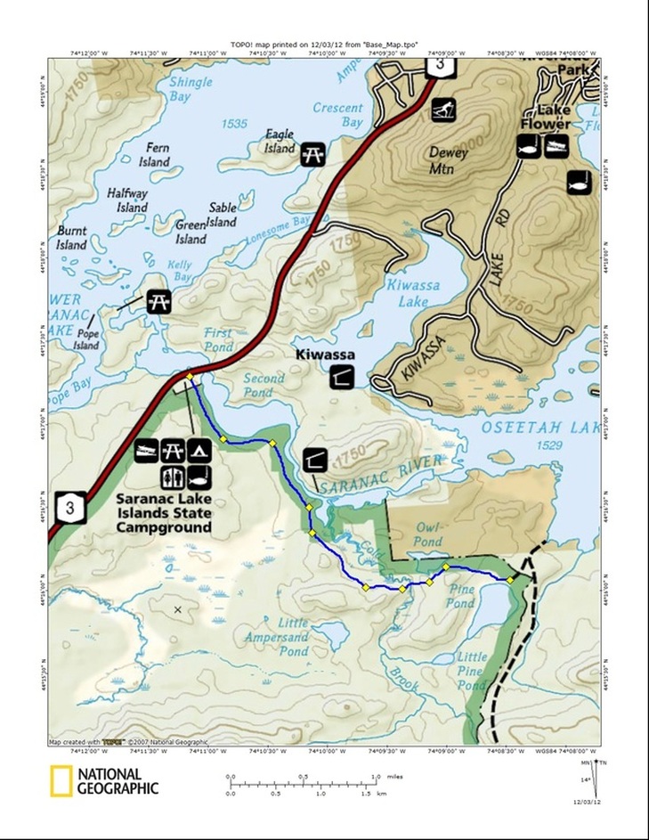
 Bonus Item – Smartphone or Google Nexus 7 Tablet SCORE 18 MSRP: ~$200 http://www.google.com/nexus/#/7 NOTE: This is the last in my series of The Baker’s Dozen of Outdoor Gear, Gadgets, and Gizmos from Worthless to Essential. For a table of the rankings and links to the entire list CLICK HERE. I appreciate your comments. Keep them coming. Thanks for following along. Jack Okay, some of you may think I’m crazy but I’m going to experiment and take my smart phone (I have an android-based phone) or my Google Nexus 7 (a 7 inch android-based tablet) on my next trip. Why would I bring a smart phone or tablet on a trip? There is no phone service where I travel so why take a phone? The battery won’t last very long without needing a charge. Here’s why; Apps! Imagine having a bird guide with bird calls or a star map allowing you to figure out what’s what in the night sky by geo-location, and so much more. Even without a phone or data connection you can have a world of resources with you like a wildflower guide with color pictures or a video of how to tie that important knot that you haven’t been able to master. It would be like having all your nature guides with you except that not only would you have the text and color photos but you could have video and audio. You wouldn't have to walk by a flower without learning what it was. You wouldn't have to listen to a bird call without know what bird it was. I’m taking my Google Nexus 7 on my next trip and I’ll let you know how it works.  Here’s a list of a few apps I might bring with me. Keep in mind that I have only used the Google Sky Map. I do not have any experience with the others. Let me know what your favorite outdoor apps are. (The links are for the Android version of these apps but iPhone versions of these apps exist as well.)
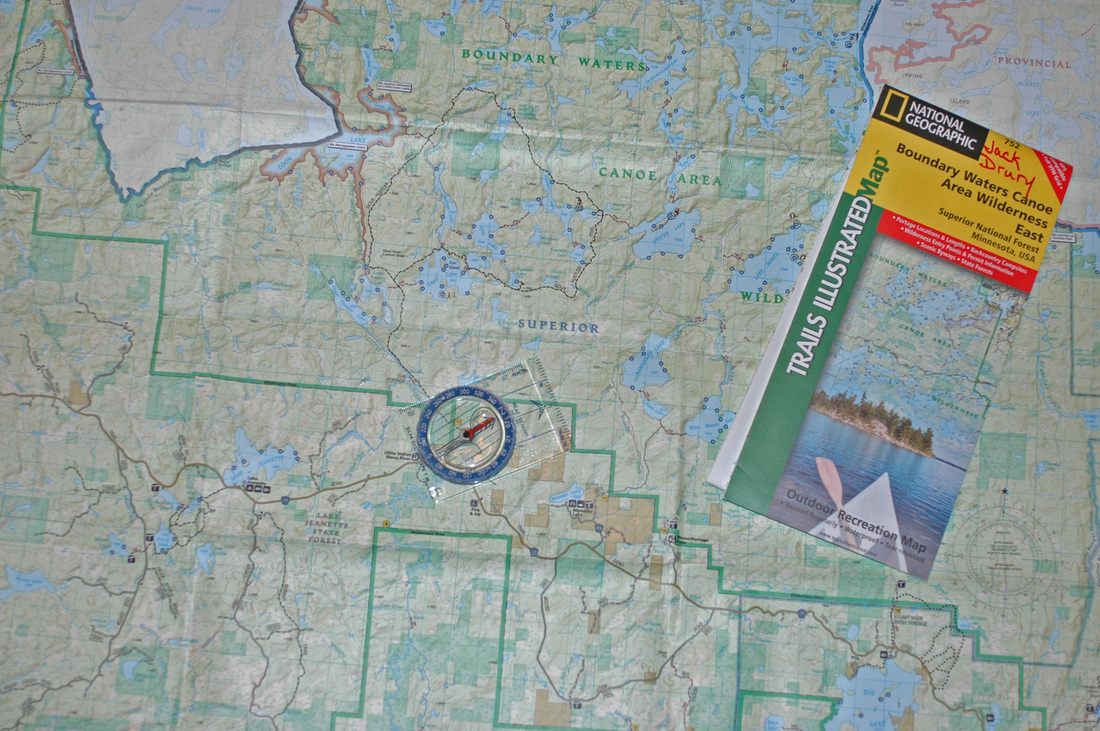 Item 1 – Map & Compass
SCORE 25 MSRP: ~$24.00 Map of the Boundary Waters Canoe Area:· http://www.amazon.com/Boundary-Waters-Canoe-Area-Wilderness/dp/1597754137/ref=sr_1_2?ie=UTF8&qid=1349232380&sr=8-2&keywords=bwca+maps Compass http://www.google.com/products/catalog?q=silva+compass&hl=en&rlz=1C1CHFX_enUS452US452&prmd=imvns&bav=on.2,or.r_gc.r_pw.r_qf.&biw=1280&bih=713&um=1&ie=UTF-8&cid=281223987299714260&sa=X&ei=b6drUPKKFeLs0gGU44A4&ved=0CGkQ8wIwBA What! How can a map and compass be the number one item? Well, they met all my criteria. I used them every day. (Well the map anyway.) The map was always with me in the canoe. Although the GPS was usually on I referred to the map more often than I did the GPS. The map and compass perform flawlessly. They are light, compact, and durable thanks to the maps’ being made of waterproof tear-resistant material. They were essential for our safety, more reliable than a GPS, and having a map to read every day is most enjoyable. I might go without a GPS but I would never go without a map and compass. Tomorrow I share the bonus item. The one item I did not bring but I might on my next trip. Stay Tuned. FINAL EVALUATION: A good map and compass are the perfect items. Of the items on my list they are arguably the only essential ones. Don't leave home without them! To see item 2 click HERE To see the evaluation criteria click HERE |

Jack Drury's Leading E.D.G.E. Blog
Sharing Observations on Education, Wilderness, and  Jack with his wife Phyliss and Yellow Lab Cedar on the shore of Lower Saranac Lake. About the AuthorThis blog was created and is maintained by Jack Drury with contributions from Bruce Bonney. Jack and Bruce have been working together since 1984 providing professional development in four areas: Categories
All
Leading E.D.G.E. is proud to be a founding partner of the Adirondack Forest Preserve Partnership 
Links:Archives
March 2015
 |
 RSS Feed