A trail that could be made a destination close to downtown Saranac Lake.
Introduction
The effort by the Adirondack Recreation Trail Advocates (ARTA) to create “a contiguous recreation trail from Lake Placid to Old Forge” is a laudable one. The concept of a recreation trail between these two communities on its surface sounds appealing. ARTA however has created the classic novel story line in that every good story has to have a protagonist, in this case ARTA, the good guys, and an antagonist, the bad guys, in this case the Adirondack Scenic Rail Road. Of course if you are the Adirondack Scenic Rail Road you may see it the other way around. History usually determines which is which. The winners end up being the protagonist and the losers the antagonist.
I prefer to look at it differently. I have an affliction called rationality. As one friend once wrote, “It’s Jack’s most honored virtue.” I like to find win-win solutions to problems. I’ve always preached to my students to use the rational decision-making/problem-solving process. One of the first steps of problem solving is to define the problem. It appears that the anti-train people define the problem as, we need more recreational trails in the Adirondacks, the railroad is a mode of transportation whose time has passed, so let’s tear up the rails and use the money from salvaging the iron and build a multi-purpose trail from Lake Placid to Old Forge. As a recreation professional with over 40 years of experience I see the problem a little differently. The problem, as I see it, is that most Adirondack communities lack easy access trails that you can reach from your home or motel room. The problem is, how can we remedy this? I’m continually amazed as I travel around the world how much easier it frequently is to find beautiful terrain to walk through in urban areas than it is in my hometown of Saranac Lake. That needs to change here in Saranac Lake as well as other Adirondack towns and villages.
The solution is much simpler than what than what the anti-train people advocate. The solution is a series of interconnected trails accessible from numerous access points. I’m going to suggest 10 trails for Saranac Lake as an example. I’m calling the list, “10 Trails We Should Build Before We Worry About Converting Rails to Trails.”
I’m going to share 1 trail a day here over the next 10 days with an accompanying map.
Before I begin let me make a few points.
Below is the map and description of the first trail. Tune in tomorrow for the second trail.
Jack Drury
The effort by the Adirondack Recreation Trail Advocates (ARTA) to create “a contiguous recreation trail from Lake Placid to Old Forge” is a laudable one. The concept of a recreation trail between these two communities on its surface sounds appealing. ARTA however has created the classic novel story line in that every good story has to have a protagonist, in this case ARTA, the good guys, and an antagonist, the bad guys, in this case the Adirondack Scenic Rail Road. Of course if you are the Adirondack Scenic Rail Road you may see it the other way around. History usually determines which is which. The winners end up being the protagonist and the losers the antagonist.
I prefer to look at it differently. I have an affliction called rationality. As one friend once wrote, “It’s Jack’s most honored virtue.” I like to find win-win solutions to problems. I’ve always preached to my students to use the rational decision-making/problem-solving process. One of the first steps of problem solving is to define the problem. It appears that the anti-train people define the problem as, we need more recreational trails in the Adirondacks, the railroad is a mode of transportation whose time has passed, so let’s tear up the rails and use the money from salvaging the iron and build a multi-purpose trail from Lake Placid to Old Forge. As a recreation professional with over 40 years of experience I see the problem a little differently. The problem, as I see it, is that most Adirondack communities lack easy access trails that you can reach from your home or motel room. The problem is, how can we remedy this? I’m continually amazed as I travel around the world how much easier it frequently is to find beautiful terrain to walk through in urban areas than it is in my hometown of Saranac Lake. That needs to change here in Saranac Lake as well as other Adirondack towns and villages.
The solution is much simpler than what than what the anti-train people advocate. The solution is a series of interconnected trails accessible from numerous access points. I’m going to suggest 10 trails for Saranac Lake as an example. I’m calling the list, “10 Trails We Should Build Before We Worry About Converting Rails to Trails.”
I’m going to share 1 trail a day here over the next 10 days with an accompanying map.
Before I begin let me make a few points.
- This list was created by me alone after spending less than an hour looking over a map of the region. I have hiked, skied, snowshoed, bicycled and/or snowmobiled almost all of these routes. The recently released Village of Saranac Lake Draft Bicycle + Pedestrian Trail Master Plan includes a number of these trails but unfortunately not all of them.
- This list is about multi-use trails but not all of these trails will be used by all modes of transportation. Some are possible to be used by all modes of travel but most will be limited to two or three. My effort was not to replicate the proposed multi-purpose recreational trail but to show that there are lots of trail development opportunities that the people of Saranac Lake should consider.
- These trails would be accessible from at least seven different trailheads but the trails would be interconnected so that users could access any trail from any one trailhead.
- This list will surely by criticized because of the many challenges to building some of these trails. Reasons like, there are too many regulatory obstacles. There are too many environmental obstacles. The cost is too high. You could say the same about the rails to trails project. Creative problem solving and good leadership can build all of these trails.
- My guess is that if you built all of these trails you will gain all the financial tourism benefits cited by ARTA’s studies.
- All distances are approximate.
- The order is random
Below is the map and description of the first trail. Tune in tomorrow for the second trail.
Jack Drury
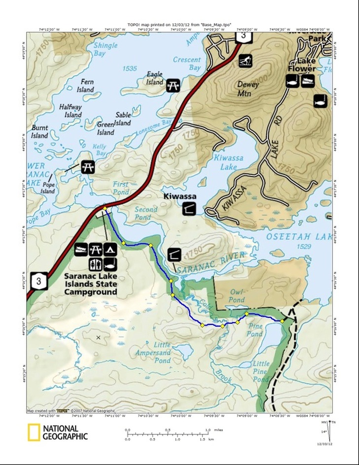
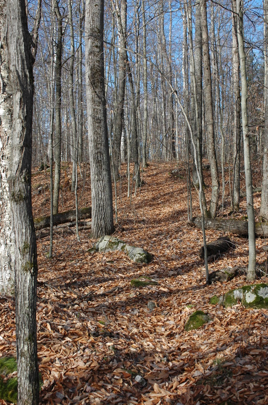
Name 1. Saranac River /Pine pond Trail | Access/DescriptionFrom the Route 3 State Bridge boat launch parking lot on Route 3 to the Averyville trail at Pine PondDifficulty - from state bridge to Pine Pond - easy. From Averyville to state bridge - moderate | Distance3 miles | Thoughts/IssuesThe parking lot already exists. It would make a great trailhead. A bridge across Cold Brook and that fact that it is a Wilderness Area are two issues. This trail and #2 would provide access to the existing trail to Averyville. |

 RSS Feed
